By NICK GOSNELL
Hutch Post
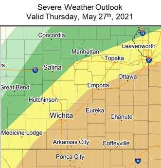
HUTCHINSON, Kan. — Forecaster Scott Roberts with the KSStorm Info weather center is concerned about the severe weather potential for south central Kansas, particularly on Thursday.
"I'm really concerned about people getting complacent with our weather situation in Kansas," Roberts said. "Thursday would be a day not to do that. Have your bug out bag, be ready. Have all your important documents gathered up so that you can grab them and go if you need to."
An enhanced risk is already in place from the Storm Prediction Center in Norman, Oklahoma just to the east of Reno County for Thursday, Roberts thinks that might change a bit to the west between now and Thursday and residents should be ready.
"We've got a lot of moisture in the ground, we've got a lot of moisture in the air," Roberts said. "Finally, the upper low pressure system that has been responsible for all of this the past couple of weeks is going to finally come out of the Rockies and push to the east and that's going to create enough impetus to send storms up and there will be enough twist in the atmosphere, especially on Thursday that we're going to have some severe weather coming."
All forms of severe weather, from wind to hail to possibly tornadoes will be on the table on Thursday somewhere in Kansas. The key as to whether it can get started here is how much cloud cover we see early in the day. If the clouds break early, there could be severe weather in the midafternoon, if the clouds hold, it could mitigate the threat in the immediate area.
CLICK
HERE to
download the Hutch Post mobile app.
CLICK
HERE to
sign up for the daily Hutch Post email news update.