MARC JACOBS
Hutch Post
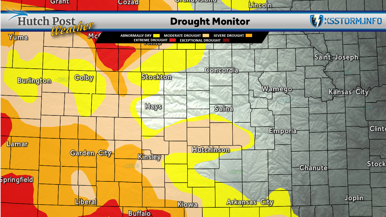
Drought conditions improved across portions of Kansas over the past week thanks to widespread rainfall, but agricultural impacts remain significant as winter wheat harvest continues across the state.
According to the latest High Plains Drought Summary, heavy rains brought one-category drought improvements across western and central Kansas as well as central Nebraska. While the moisture has begun to revive drought-stressed rangeland and pastures, agricultural experts say it arrived too late to significantly improve this year's winter wheat crop.
The U.S. Department of Agriculture reported the national winter wheat harvest was 40% complete as of June 21. Nearly half of the nation's winter wheat crop—46%—was rated in very poor to poor condition. Kansas remains among the hardest-hit states, with 55% of its winter wheat rated very poor to poor. Only Nebraska, at 83%, and Colorado, at 63%, reported worse crop conditions.

Kansas livestock producers continue to face challenges as well. Although recent rainfall has improved soil moisture and begun to green up pastures, drought conditions have left many grazing areas struggling throughout the growing season. Across the High Plains, Nebraska reported 73% of its rangeland and pastures in very poor to poor condition, followed by Colorado at 63% and Wyoming at 60%.
Nationally, weather patterns brought mixed conditions during the past week. Tropical Storm Arthur briefly formed near the middle Texas coast before moving inland near Galveston, but its associated weather system delivered widespread rainfall of 4 to 8 inches or more across portions of the Gulf Coast and Deep South. While flash flooding occurred in some areas, the rainfall also helped ease drought conditions that had persisted across much of the South.

Across the Midwest, a series of cold fronts produced scattered showers and thunderstorms, maintaining generally favorable soil moisture for summer crops despite localized wind and hail damage.
In contrast, much of the western United States remained hot and dry, increasing irrigation demands and elevating wildfire danger. One of the largest new fires, the Iron Fire near Eureka, Utah, ignited on June 19 and rapidly burned more than 37,000 acres of grass and chaparral.
Forecasters say additional rainfall will be important in determining whether recent drought improvements across Kansas continue through the remainder of the growing season. While recent precipitation has helped replenish topsoil moisture and improve pasture conditions, producers remain focused on the outlook for summer crops and the long-term recovery of grazing lands following months of dry weather.
The U.S. Drought Monitor is jointly produced by the National Drought Mitigation Center at the University of Nebraska-Lincoln, the United States Department of Agriculture, the National Oceanic and Atmospheric Administration and the National Aeronautics and Space Administration. Map data courtesy of NDMC.