MARC JACOBS
Hutch Post
The threat of dangerous wildfire conditions is increasing across much of Kansas, with the National Weather Service now issuing both fire weather watches and a Red Flag Warning ahead of strong winds and extremely low humidity expected Tuesday.
The National Weather Service office in Wichita said a Fire Weather Watch remains in effect from Tuesday afternoon through early Tuesday evening for areas along and west of Interstate 135 in central Kansas. Counties included are Russell, Lincoln, Barton, Ellsworth, Saline, Rice, McPherson, Reno, Kingman and Harper.
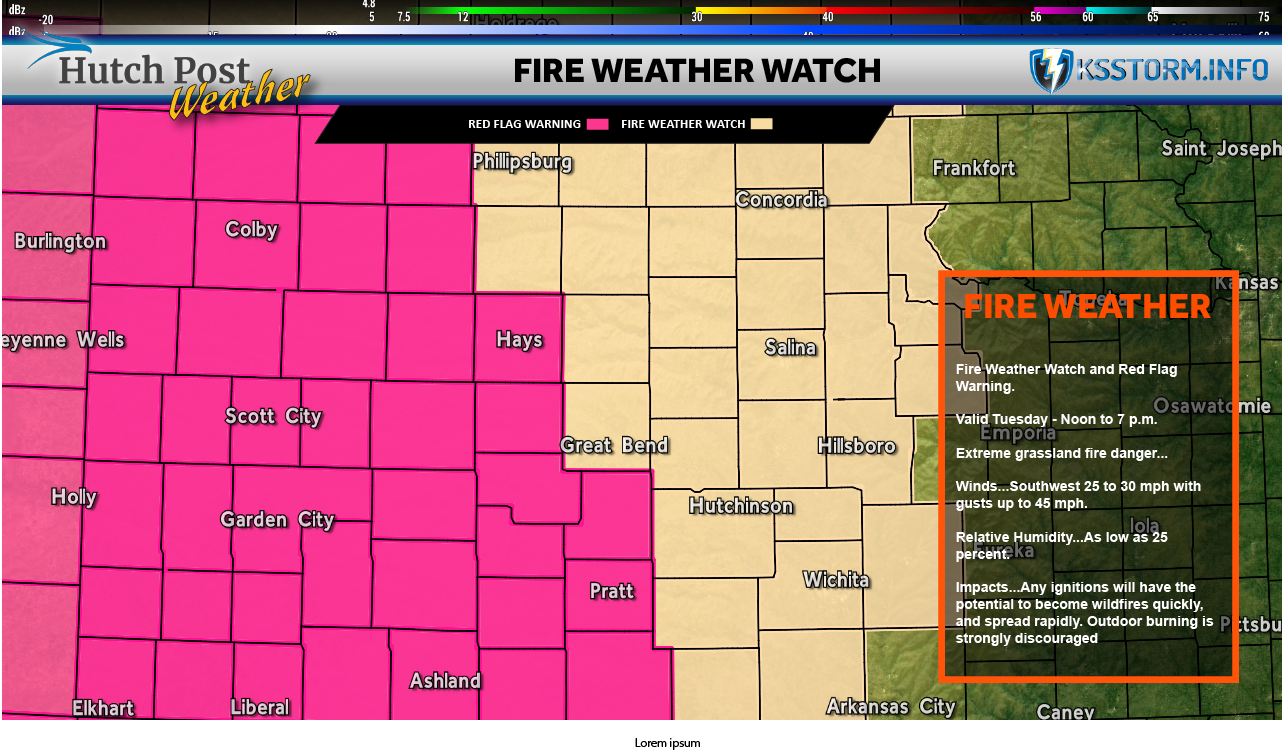
Forecasters said southwest winds of 25 to 30 mph, with gusts near 40 mph, combined with relative humidity as low as 19 percent, could allow any fires that start to spread rapidly. Outdoor burning is strongly discouraged.
Farther west, conditions are expected to be more severe. The National Weather Service office in Dodge City upgraded portions of southwest Kansas to a Red Flag Warning, which will be in effect from noon to 8 p.m. Tuesday. The warning covers a large area, including Trego, Ellis, Scott, Lane, Ness, Rush, Hamilton, Kearny, Finney, Hodgeman, Pawnee, Stafford, Stanton, Grant, Haskell, Gray, Ford, Edwards, Kiowa, Pratt, Morton, Stevens, Seward, Meade, Clark, Comanche and Barber counties.
In those areas, southwest winds are forecast at 25 to 45 mph, with gusts of 50 mph or higher. Relative humidity could fall as low as 10 percent, creating extreme fire behavior potential.
A Fire Weather Watch means critical fire weather conditions are possible, while a Red Flag Warning indicates those conditions are expected or imminent. Officials warned that the combination of strong winds, low humidity and warm temperatures could allow fires to ignite easily and spread quickly.
Residents are urged to avoid outdoor burning and activities that could spark fires, and fire crews and emergency officials are advised to remain on heightened alert as conditions develop Tuesday.